题干
Assume the coasting is an infinite straight line. Land is in one side of coasting, sea in the other. Each small island is a point locating in the sea side. And any radar installation, locating on the coasting, can only cover d distance, so an island in the sea can be covered by a radius installation, if the distance between them is at most d.
We use Cartesian coordinate system, defining the coasting is the x-axis. The sea side is above x-axis, and the land side below. Given the position of each island in the sea, and given the distance of the coverage of the radar installation, your task is to write a program to find the minimal number of radar installations to cover all the islands. Note that the position of an island is represented by its x-y coordinates.
Input
The input consists of several test cases. The first line of each case contains two integers n (1<=n<=1000) and d, where n is the number of islands in the sea and d is the distance of coverage of the radar installation. This is followed by n lines each containing two integers representing the coordinate of the position of each island. Then a blank line follows to separate the cases.
The input is terminated by a line containing pair of zeros.
Output
For each test case output one line consisting of the test case number followed by the minimal number of radar installations needed. “-1” installation means no solution for that case.
假设滑行是一条无限直线。海岸的一边是陆地,另一边是海洋。每个小岛都是位于海边的一个点。而任何雷达装置,定位在海岸上,只能覆盖d距离,所以一个半径的装置可以覆盖一个岛屿,如果他们之间的距离不超过d。
我们用笛卡尔坐标系,定义滑行是x轴。海洋面在x轴上方,陆地面在x轴下方。给定每个岛屿在海上的位置,给定雷达安装的覆盖距离,你的任务是编写一个程序,找出覆盖所有岛屿的最小雷达安装数量。注意,岛屿的位置由它的x-y坐标表示。
Input
输入由几个测试用例组成。每种情况的第一行包含两个整数n (1<=n<=1000)和d,其中n为海上岛屿的数量,d为雷达安装的覆盖距离。接下来是n行,每一行包含两个整数,代表每个岛屿的位置坐标。然后用空行分隔大小写。
输入以包含一对零的行结束。
Output
对于每个测试用例输出一行,包含测试用例编号,然后是所需雷达安装的最小数量。“-1”安装意味着这种情况下没有解决方案。
测试案例
Input
1 | 3 2 |
Output
1 | Case 1: 2 |
题意与思路
题意为给你若干个海岛的坐标,你需要在海岸线上布置雷达,雷达的覆盖面是半径为 d 的圆形,要求你给出一种布置雷达的方案,使得雷达总数最小。
首先,我们需要判断布置雷达覆盖所有岛屿的方案是否存在,判断条件为:
1 | 岛屿距离海岸线的距离 <= 雷达覆盖半径 |
如果方案存在,接下来我们开始探索具体的方案。
对于某个海岛,以其坐标为圆心、d 为半径画圆,在这一范围内布置雷达可以检测到该海岛。由于雷达只能布置在海岸线上,所以实际上,只有该圆与 x 轴相交的区间上有雷达,才能覆盖到这一海岛。
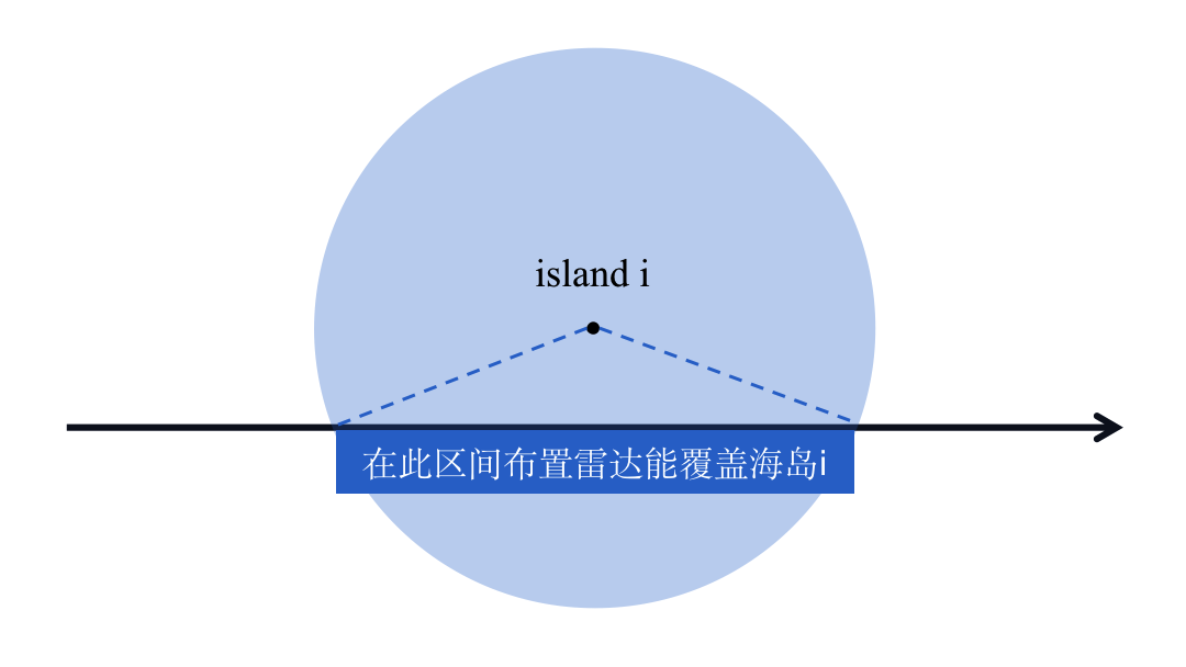
因此,我们可以以海岛为圆心、d 为半径画出若干个圆,尝试遍历这些圆,讨论它们与 x 轴的相交情况以及它们彼此之间的相交情况,就有可能解决这一问题。
按照一般习惯,我们尝试从左到右遍历这些圆,在遍历的过程中布置雷达。雷达可以布置在区间内的任意位置,但是为了使雷达总数最小,我们需要尽可能地让每一个雷达覆盖到更多的海岛。
在从左到右遍历时,我们在当前区间范围内布置一个雷达,并希望它尽可能地照顾到更多右边的海岛,那么这一雷达最佳的位置应该是该区间的右端点。
由此,我们得出了遍历过程中布置雷达的思路:
- 在第一个岛屿对应区间的右端点布置雷达,记录雷达的位置
raderLoc - 考察下一个岛屿,如果:
- 当前处于
raderLoc位置的雷达可以覆盖到该岛屿,则继续步骤2; - 当前处于
raderLoc位置的雷达无法覆盖到该岛屿,则在该岛屿对应区间的右端点布置下一个雷达,并更新雷达的位置raderLoc;
- 当前处于
1 | int rader = 1; // 记录雷达总数 |
解决了如何布置雷达的问题,还需要解决岛屿的顺序问题。给岛屿排序的思路有很多,例如:
[思路1] 根据岛屿横坐标排序
[思路2] 根据岛屿的区间左端点排序
[思路3] 根据岛屿的区间右端点排序
我们考察下面这种情况:
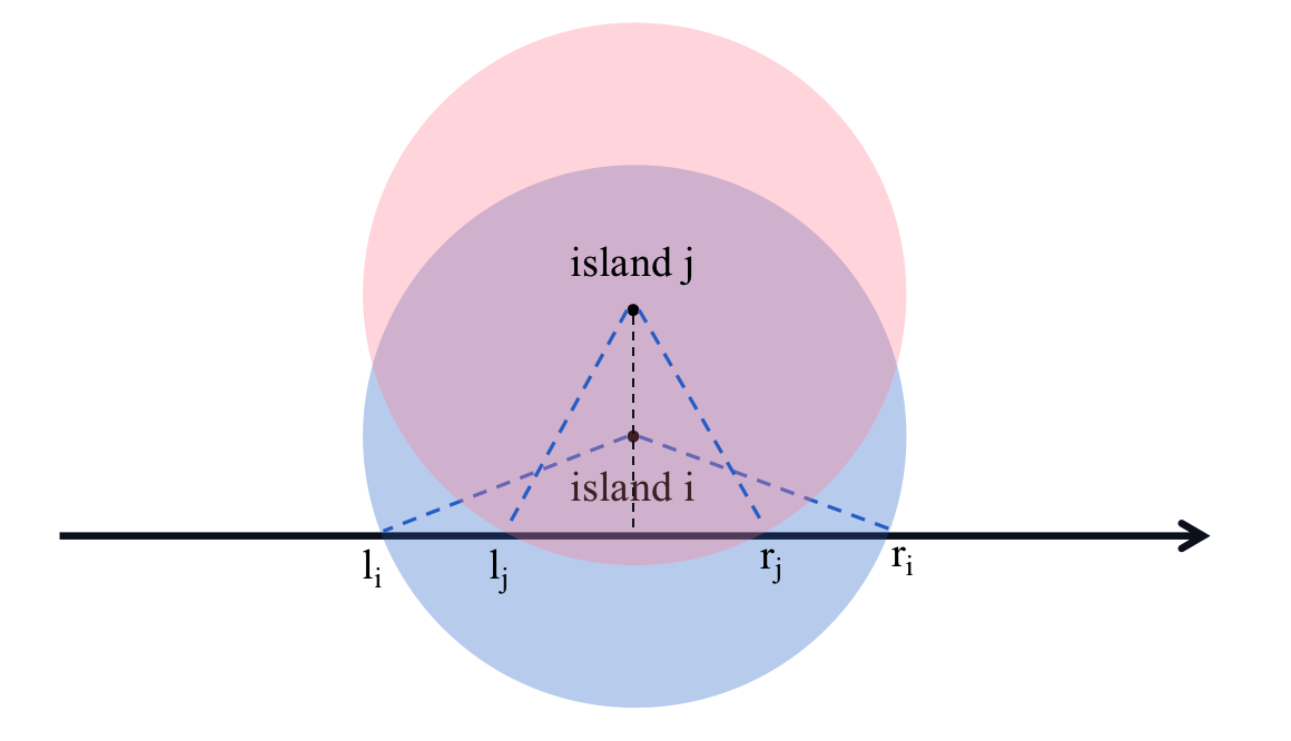
岛屿 i 和岛屿 j 的横坐标相同,对应区间分别为 [li, ri] 和 [lj, rj],此时:
-
如果按照区间左端点排序,则
li < lj,遍历时:- 首先考虑岛屿
i,雷达被布置在raderLoc = ri - 接下来考虑岛屿
j,当前雷达位置raderLoc = ri,无法覆盖到岛屿j,因此在岛屿j的右端点设置下一个雷达raderLoc = rj
然而,这样就导致岛屿
i所对应的区间中出现了两个雷达,分别位于ri和rj,产生了浪费,所以这种思路出了问题;当然,你也可以增加对这种情况的判别,不增设雷达,而是把处于
ri的雷达挪动到rj,也是一种可行的思路。 - 首先考虑岛屿
-
如果按照区间的右端点排序,则
rj < ri,遍历时:- 首先考虑岛屿
j,雷达被布置在raderLoc = rj - 接下来考虑岛屿
i,当前雷达位置raderLoc = rj,可以覆盖岛屿i,无需布置新的雷达,与推论相符
- 首先考虑岛屿
因此,我们*采用*[思路3]对所有岛屿进行排序。
我们采用结构体来存储岛屿数据,并定义排序规则 cmp():
1 | struct node{ |
需要特别注意,当有海岛距离海岸线超过 d 即方案不存在时,亦须先等待输入结束,再输出 Case x: -1,而不能检测到该岛屿时直接输出,否则会报错,呜呜呜呜呜呜呜
需要特别注意2,输入岛屿数据的时候不要用 cin,要用 scanf,因为 cin 比 scanf 慢,会报超时呜呜呜呜呜呜呜
题解
1 |
|
